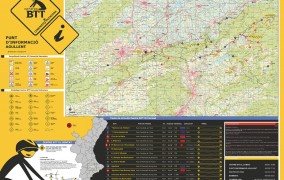
BTT ROUTES

La Ermita de Sant Vicent Ferrer of Agullent is Official Information Center MTB route network promoted by the Valencian Agency of Tourism. From this point leave 5 circular routes to tour many towns and places much of the region of the Vall d’Albaida and the Comtat.
![]()
ROUTE 10. AGULLENT (descargar .gpx)
difficulty: 2 | distance: 11,85 km | slope: 375 m | wikilock
![]() ROUTE 11. AGULLENT-CASA BUENOS AIRES (download .gpx)
ROUTE 11. AGULLENT-CASA BUENOS AIRES (download .gpx)
difficulty: 3 | distance: 23,53 km | slope: 692 m | wikilock
![]() ROUTE 12. ONTINYENT-BOCAIRENT-VIA XURRA (download .gpx)
ROUTE 12. ONTINYENT-BOCAIRENT-VIA XURRA (download .gpx)
difficulty: 4 | distance: 55,11 km | slope: 1.040 m | wikilock
![]() ROUTE 13. OMBRIA DEL BENICADELL (download .gpx)
ROUTE 13. OMBRIA DEL BENICADELL (download .gpx)
difficulty: 4 | distance: 43,81 km | slope: 1.944 m | wikilock
![]() ROUTE 14. CAMÍ VELL D’ONTINYENT A GANDIA (download .gpx)
ROUTE 14. CAMÍ VELL D’ONTINYENT A GANDIA (download .gpx)
difficulty: 3 | distance: 41,75 km | slope: 667 m | wikilock
*Difficulty: 1 Very easy- 2 Easy – 3 Hard – 4 Very hard