fbpx

phone96 290 70 80

info@turismeagullent.com

TRAIL


FONT JORDANA> Covalta> FONT JORDANA
HIGH LEVEL 611 Mts positive slope. DISTANCE 16.80 km.

1. We left the paved road behind the Font Jordana (booths) and climb for about 500 meters, until, right where the ascent, leaving a paved road to the right with two red marks. Taking this path will continue up to the next intersection where there is a mountain trail to the left.2. This path will lead shortly to the Engineers, path we will take to the left, soon crossing the Ravine “Penyascals” and the ravine de la” Font de la petaca” of the Flask (trademark of PR).

3. Following the path will reach a path we will take a left down to the “Font del Patge”(single point of provisioning of water to the Covalta) great place for breakfast and enjoy the views of the Vall d’Albaida.

4. Continue down to take a fork to the right.

5. Follow the path to a junction just a curve there. On the right (PR signal) goes toward the Covalta, where already spotted the cross at the top.

6. Do not leave the road until you see a path to the right that leads directly to the Covalta (there is a mark to a pine PR)

7. We expected a tough climb up the Covalta. We will leave a trail to the right and reach the Covalta (source inside the cave and wonderful views of the valley).

8. For we will take the same path back down to the junction we left before, now on our left.

9. The trail goes on for 1 km of a road where stands “the Coll de Santa Ana”, path we will take to the right (also leaving a trail on the left that leads to the Valley of Agres).

10. A 1 km approximately find a path to the left. We continue straight until a crossroads marked with a signpost (“Foieta dels Carros”, “old way Ontinyent in Agres” “way of Cuco”) take the road to the right of the Cuco.

11. Down the path, leave a trail to the right, continue to find the path leading down to the “Font del Patge” We turn to the left.

12. We will continue to find the intersection of two roads and the Cuco Trail, which we will take.

13. It’s time to get off without leaving the path up to the Engineers. We turn to the left.

14. Finally we will meet soon with the path down to the “Font Jordana”.


JORDANA FONT> Covetes Alfafara> FONT JORDANA
HIGH LEVEL 418 Mts positive slope. DISTANCE 13.80 km.

1. To the right of the “Font Jordana”, about 200 meters there is a path that leads to the Path of Engineers, which we will take to begin the route. Once the Path Engineers, turn left and continue up the path that will lead us to the Way of Cuco (right).2. Climb all the path to a fork, take the right path.

3. That will lead us to the path of Cuco, so we continue to the right (you can see nests right)

4. Continue along the path until you reach the crossroads of the Cuco, Ontinyent-Agres way.

5. We leave the road Ontinyent-Agres, approximately 1 km there is a turnoff on the right path down to Agullent, we will not take to continue straight on the road until you find Torrater Alfafara path, veering to the left, direction ” Small Valley Agres-Alfafara “. This is a continuous zigzag path, and a bend there is a right way, we will take.

6. After a few meters, we can see Climbing School on the right and a ruined house, then take another road to the right (left pit and a path that’ll take). We left the path to the right, continuing down the road to an old house Renfe. There is a fountain on the right and a path to the left, below the road bridge.

7. We continued down the road and, wandering in the left path to reach a boardwalk almost certainly find it dry in summer. Without crossing the river, continue along his side, keeping to the right. Be careful because by the end of the road, we will have to cross the river on a trail that goes to the right, and finally to the caves.

8. To return, take the same road until you cross over the railroad tracks. Once the water in response fountain, we headed to the road on the left which soon becomes path. This step is very steep and the road will lead us “Torrater”.

9. We meet on the left, the road down to the House of “Torrater”, which we will take no Go straight to the path we take Agullent left.

10. Continue down this path for a while until the road appears with concrete, where there is a path (PR) we take the right, leaving the road.

11. Following the main trail marked with (PR) arrive at the detour (left) of the path 5 ‘will lead to “Font Jordana”

JORDANA FONT> Torrater> FONT JORDANA

MIDDLE LEVEL 306 Mts positive slope.
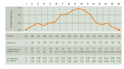
DISTANCE 11.60 km.

1. We started the trip down the path to the right of the “Font Jordana”, that takes us to the path of the engineers, where we turn right.

2. While this path, cross the ravine “ Lisa Peña” and “ dels clots” A little later we will get a path to the left and right, which reject to continue for Engineers, until we get to a paved road, which descends to the pool Agullent.

3. About 5 meters down, right next to a tower of light, we have the way down to the “Font Maciana” (great place for breakfast or spend the day).

4. Once in the “Font Maciana”, we take the path that lies ahead (rejecting the path of left signpost) to take us to the path of Engineers.

5. Turn right and follow the path of the Engineers to a junction of paths.

6. We head to the left following the marks of PR, to ascend the ravine “Peña Alta” to the Path of Engineers, which comes from Ontinyent, where we turn right.

7. Soon cross a road perpendicularly and ravine of “Galindo”, up the path crossing a road. We’ll take the road to the left.

8. Arrive shortly “Torrater” the road and we turn right

9. We turn again to the right on a paved road. Only a few meters separate us from the High of the Pots (magnificent views of the “Vall d’Albaida” and “Valleta Agres”)

10. To return, take the same path to the “Torrater”, and we turn on the second left. (Be careful, as it is a narrow path about a meter wide, and it is easy to happen!)

11. Walk over a spur, watching right “la Peña Alta”, crossing the path of Engineers.

12. We continue straight on the road (be careful, because the descent is very rocky and quite steep loose). At the end of the descent to leave behind and we will find a crossing of paths. We’ll get on the right, toward the “Font Maciana”, and let you climb the “Peña Alta”.

13. You will not leave this path to reach the “Font Maciana”, despising the trails left out.

14. Follow the path without entering the “Font Maciana”, leaving on our left, until you reach the asphalt road.

15. We’ll take the road to the left and go down to the pool, go round by the left, and take the road to the right. Continue to the chapeof San Vicente

16. Once in the chapel, we go down to the Source Via Crucis Jordana.

JORDANA FONT> Source Patge> FONT JORDANA
MIDDLE Nivell positive slope 235 Mts. DISTANCE 6.8 km.

1. We left the paved road behind the “Font Jordana and serves booths, and walked for about 500 meters. Just when we finished up, there is a path to the right where you will find two red marks. Taking this path will continue up to the next intersection, where there is a mountain trail to the left.

2. This path will lead us to the path of the engineers, we will take a left. Soon after crossing the Ravine “Penyascals” (PR brands) and Ravine “ Font de la Petaca”

3. Following the path we left a path down to the Source “Patge”, this is the only point of water supplies

4. To return, take the same path in the opposite direction (now is a rise) to a junction where a road to the left and to the right path, we take the path of the Cuco.

5. Shortly down the road, we will see a path that connects the left but we continue in the same direction, after doing a zigzag, up to the Path of engineers take a left.

6. A few meters down the path will the “Font Jordana” on our right.

JORDANA FONT> Font Maciana> FONT JORDANA
LOW Nivel positive slope 110 meters. DISTANCE 3.36 km.

1. We started the trip down the path to the right of the “Font Jordana” that takes us to the path of Engineers, where we turn right.2. While this path, cross the ravine and Lisa Pena of “Clots”. A little later we will get a path to the left and right to reject Engineers to continue on until we came to a paved road, which descends to the pool Agullent.

3. About 5 meters down, right next to a tower of light, we have the way down to the Source Maciana (great place for breakfast or spend the day).

4. To take a path back to the left where you will find a flag pole. This trail runs parallel to the road and take us to the asphalt road.

5. Turn left to go down to the local swimming pool, which will border on the left (pool or our right) and continue along the road to the chapel of San Vicente.

6. Once in the Hermitage we just go down to the Via Crucis Jordana